TorontoOntario · 36 tours
 Niagara FallsOntario · 25 tours
 New York CityNew York · 30 tours
 Las VegasNevada · 8 tours
 San FranciscoCalifornia · 16 tours
 VancouverBritish Columbia · 17 tours
 DubaiUAE · 54 tours
 Abu DhabiUAE · 5 tours
 Buenos AiresArgentina · 23 tours
 AthensGreece · 31 tours
 AucklandNew Zealand · 38 tours
 CancunMexico · 54 tours
No destinations match “”. Try searching all tours instead — that search understands full questions, not just place names.
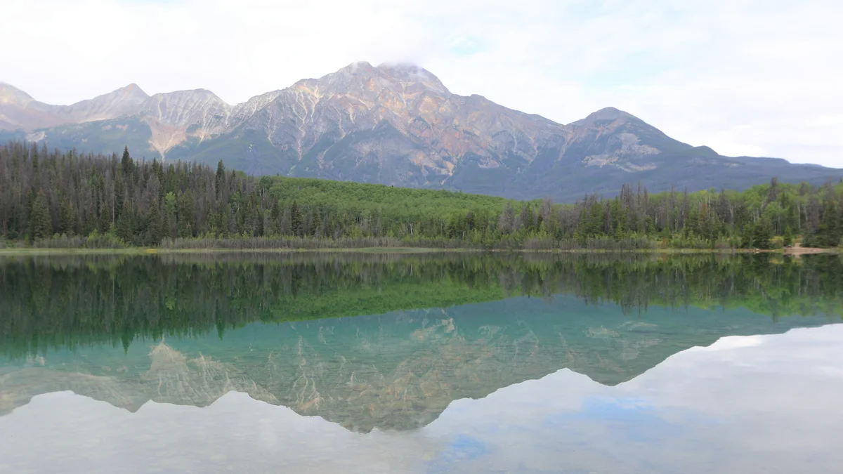
Just a few minutes from the Jasper townsite, Pyramid Lake takes its name from the sharply pointed mountain that towers over it and reflects almost perfectly in its calm water on a still day. A small wooden bridge connects the shore to Pyramid Island, and the lake is a popular spot for canoeing, paddleboarding, and simply taking in one of the most classic mountain-lake views in the Canadian Rockies.
Visitor guide
Pyramid Lake is a small kidney-shaped lake in Jasper National Park, about 5 kilometres by road from Jasper townsite. It lies at the foot of Pyramid Mountain, whose pyramid-like profile gives both landmarks their names and fills the view across the water.
Wikipedia gives the lake an area of about 1.2 square kilometres, a length of about 2.7 kilometres, a width of about 0.5 kilometres and an elevation of 1,180 metres (3,870 feet). It drains into the Athabasca River through Pyramid Creek, which runs roughly 2 kilometres. The Athabasca itself is a 1,231-kilometre river that empties into Lake Athabasca; its name is traced to a Woods Cree word, and from about 1778 the river formed part of a main fur-trade route between the Mackenzie River and the Great Lakes. Pyramid Lake's modest size makes it calm and easy to explore, in contrast to larger lakes farther afield.
Pyramid Mountain rises to 2,766 metres (9,075 feet), with a prominence of about 761 metres, just under 10 kilometres northwest of Jasper. James Hector named it in 1859 for its shape as seen from the Athabasca River valley; he was the geologist on the Palliser expedition across western Canada, a survey that ran from 1857 to 1860, and later led the Geological Survey of New Zealand. One record says the name was officially adopted in 1951. The mountain is a major headwater of the Athabasca and belongs to the Victoria Cross Ranges. The first ascent was made by George Kinney with guide Conrad Kain, and the easiest route is described as a relatively easy scramble on the eastern slopes, reached by a steep fire road from the Pyramid Lake parking area. That is a serious day for experienced hikers rather than a stroll, so check conditions with Parks Canada.
Conrad Kain, born in Austria in 1883, came to Canada in 1909 as the Alpine Club of Canada's first professional guide and is credited with 69 first ascents here, including Mount Robson in 1913. The Victoria Cross Ranges are a subrange of the Front Ranges covering about 678 square kilometres, in which five of the 19 peaks are named for Canadian Victoria Cross recipients. The highest is Snaring Mountain at 2,931 metres. The area has a subarctic climate, with cold, snowy winters and mild summers.
A short road leads to a small parking area, and from there a wooden footbridge crosses to Pyramid Island. The island has benches, picnic tables and a small open wooden shelter, and it is a favourite spot for mountain-reflection photographs, especially in calm early light. Pyramid Lake Lodge sits at the southeast point of the lake, and picnic sites and boat ramps line parts of the shore. Check Parks Canada for current rules on boating and fishing licences and for any restrictions on the water.
Jasper National Park began as Jasper Forest Park, created by a federal order in council on 14 September 1907, and became a national park in 1930. Parks Canada's current management plan gives its area as 11,228 square kilometres, was inscribed on the UNESCO World Heritage list in 1984 as part of the Canadian Rocky Mountain Parks, and was designated a dark-sky preserve by the Royal Astronomical Society of Canada in 2011. The park takes its name from Jasper Haws, a fur trader who took charge of a North West Company post in 1817. The railway divisional point that became the townsite was first called Fitzhugh in 1911 and renamed Jasper in 1913.
Patricia Lake, linked to Pyramid Lake by roads and trails, was the site of a secret Second World War trial. In 1943 a prototype of Project Habakkuk, a proposed aircraft carrier made of pykrete, an ice-and-wood-pulp mix, was built there. Wikipedia reports the prototype was about 60 by 30 feet, built by conscientious objectors who were not told its purpose, and that the lake was chosen for its cold, remote setting and rail link at Jasper. Accounts differ on how the model ended, and one says it took several summers to melt fully, but a 1985 dive found remains on the lake bottom at depths of roughly 26 to 43 metres. The lake is named for Princess Patricia of Connaught.
Pyramid Lake Road and a network of trails connect the lake with Jasper townsite and with Patricia Lake and Cabin Lake, as well as the routes up Pyramid Mountain. This makes it a pleasant place to combine a short walk with a picnic. Winter use varies, so check current conditions before going.
Pyramid Lake works well as an unhurried half-hour to hour stop on the way into or out of town, or as an early-morning photograph before the day warms up. On a Voyzo private tour your driver collects you door to door and can include the lake alongside other Jasper stops such as the SkyTram and Athabasca Falls, adjusting the order to the weather and light.
See every tour and attraction we cover in Jasper.