TorontoOntario · 36 tours
 Niagara FallsOntario · 25 tours
 New York CityNew York · 30 tours
 Las VegasNevada · 8 tours
 San FranciscoCalifornia · 16 tours
 VancouverBritish Columbia · 17 tours
 DubaiUAE · 54 tours
 Abu DhabiUAE · 5 tours
 Buenos AiresArgentina · 23 tours
 AthensGreece · 31 tours
 AucklandNew Zealand · 38 tours
 CancunMexico · 54 tours
No destinations match “”. Try searching all tours instead — that search understands full questions, not just place names.
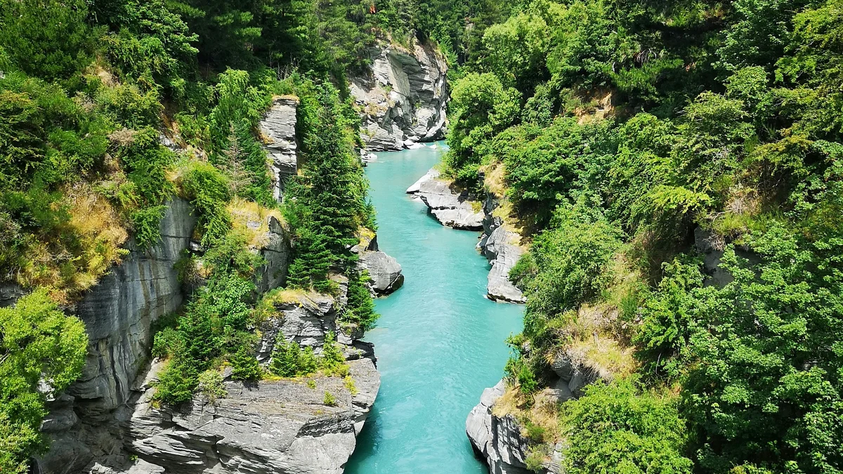
This dramatic gorge outside Queenstown was carved by the Shotover River and threaded with a narrow cliff-edge road built by hand during the 1880s gold rush to reach remote mining claims. The Shotover's glacial meltwater gives it a striking turquoise color as it winds between sheer rock walls. Today the canyon is best known for 4WD tours, jet boating, and the Pipeline Bungy jump over the gorge.
Visitor guide
Skippers Canyon is a historic, scenic gorge about 22 km long, a few kilometres north of Queenstown in New Zealand's Otago region. Carved by the Shotover River, it was a centre of the 1860s gold rush and is known today for its narrow heritage road, its stone bridge approaches and its goldfield remains.
According to Wikipedia, William Gilbert Rees named the Shotover River, and miners later called it the richest river in the world, though no official records confirm that. In November 1862 Thomas Arthur and Harry Redfern found about four ounces of gold within three hours near present-day Arthurs Point, starting one of the largest rushes in Otago. Miners then followed the river upstream into the gorge.
Two Maori miners, Dan Ellison (Raniera Erihana) and Hakaria Maeroa, made a major find at Maori Point, collecting about 300 ounces before nightfall. This find founded Charlestown, which had hotels, bakers, a post office, a bank and a police station. Its population peaked near 1,000 but fell to about 400 by 1864, and today only a few stones and a small plaque remain.
The canyon and Skippers Point are named after Malcolm Duncan, a Northern Irish-born miner nicknamed Skipper from years on American ships, who found gold at Skippers Creek in 1862. Skippers Point once supported six hotels. Other miners worked claims until the early 1900s, and the remains of water races, dams, sluicing and tailings are still visible. The restored Skippers School and the cemetery also remain. Skippers Point's population peaked near 1,000 and had settled to around 200 by 1864, and in 1866 a hydroelectric station at Dynamo sent power about 3 km to Bullendale to run an air compressor for a stamping plant, which Wikipedia says was not profitable.
Early miners used rough horse tracks, and pack horses were sometimes lost with their supplies. Surveying began around 1883, and four contractors built the road in stages over about seven years. Many sections still resemble their 1890 condition. The soft local rock turns to dust in dry weather and greasy mud in wet weather, which made upkeep very costly. Heritage New Zealand has protected the road since 2006. Today it is known for narrow one-lane sections, steep grades and sheer drops, which is why many visitors prefer to leave the driving to a local professional.
A first suspension bridge, begun in 1866, crossed only about six metres above the water and was prone to flood damage. Work on a much higher replacement began in 1898 and took about three years, and the Minister of Mines opened it in March 1901. The bridge spans a gorge about 91 metres above the river, and the stone approaches of the older bridge are still visible from the road.
Skippers Canyon is listed on Wikipedia as a filming location for the Ford of Bruinen in Peter Jackson's Tolkien films. A private guided trip suits the canyon's rough, narrow road and its scattered heritage sites.
See every tour and attraction we cover in Queenstown.