TorontoOntario · 36 tours
 Niagara FallsOntario · 25 tours
 New York CityNew York · 30 tours
 Las VegasNevada · 8 tours
 San FranciscoCalifornia · 16 tours
 VancouverBritish Columbia · 17 tours
 DubaiUAE · 54 tours
 Abu DhabiUAE · 5 tours
 Buenos AiresArgentina · 23 tours
 AthensGreece · 31 tours
 AucklandNew Zealand · 38 tours
 CancunMexico · 54 tours
No destinations match “”. Try searching all tours instead — that search understands full questions, not just place names.
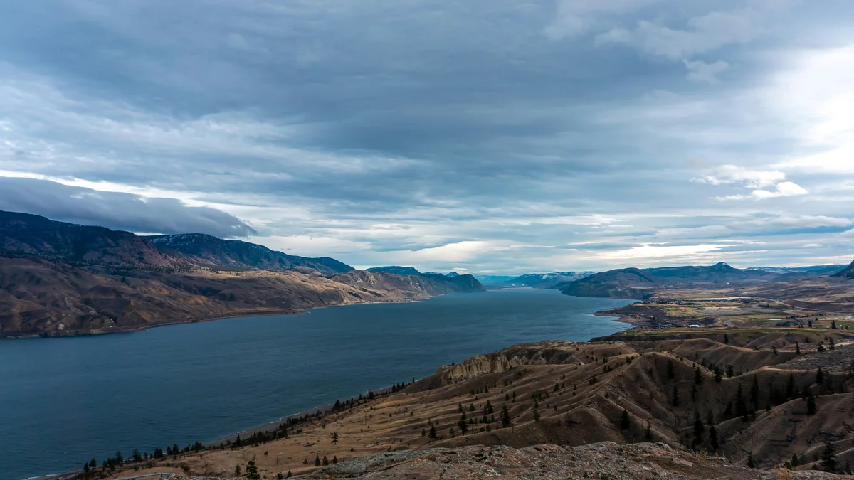
A long lake west of the city framed by semi-arid hills, railway lines, and the Thompson River valley.
Visitor guide
Kamloops Lake is a long, narrow widening of the Thompson River just west of the city of Kamloops, British Columbia. It runs through steep, dry hills of bunchgrass and sagebrush, a landscape far from the coastal rainforest most visitors imagine.
Per Wikipedia, the lake is about 29 km long and 1.6 km wide, with a surface area near 52 square kilometres, a maximum depth of 152 m and a surface elevation around 335 m. The Thompson and Tranquille rivers flow in, and the Thompson River is the only outflow. Water levels are unregulated and usually rise about 9 m from winter lows until late June, with beaches widening in July and August as levels drop. Because the South Thompson carries relatively warm water from the Shuswap Lakes, the lake rarely freezes.
The lake was once much longer; Wikipedia notes silt cliffs about 100 m above the present water level mark ancient lake bottoms, and a gravel moraine near Savona suggests a glacier once ended there. The area sits in the Coast Mountains' rain shadow with roughly 10 inches of precipitation a year, so vegetation is mostly bunchgrass and sagebrush, with pockets of Douglas-fir and ponderosa pine. Mule deer and bighorn sheep graze the slopes in spring, and the surrounding land is largely cattle ranching, per Wikipedia. Both the CN and CP railways run along its shores.
The name Kamloops is an English form of the Secwépemc name Tk'emlúps, usually translated as 'where the rivers meet' or 'meeting of the waters'. Secwépemc history in the region reaches back around 10,000 years, according to Tk'emlúps te Secwépemc, and for thousands of years First Nations used the trails and waterways here to travel between hunting, fishing and trading areas.
Savona, at the lake's west end, takes its name from a ferry across the Thompson that François Saveneux began around 1858 during the Fraser Canyon gold rush (sources vary on the exact year, and the name was anglicised to Savona). The Big Bend gold rush then prompted a wagon road from Cache Creek, built by Gustavus Blin Wright and opened in April 1866 with stagecoach service, and a road on to Kamloops was completed in 1869.
Wikipedia says the steamboat Marten, launched in May 1866 with a boiler hauled in by ten mules, was the first steamboat on Kamloops Lake and linked Savona with Seymour Arm; it was wrecked in 1877. The Canadian Pacific railhead reached Savona in December 1884 and Kamloops in July 1885. The Canadian Northern line later passed through in December 1914. Nearby, the Skeetchestn Band, whose traditional name was restored in 1985, has its main reserve on the Deadman River northwest of Savona.
Tranquille, at the east end, was a tuberculosis sanatorium that opened in 1907 and was first called the King Edward VII Sanatorium. A small community grew around it, with a farm, gardens, a school and other facilities. It closed in 1958 and reopened in 1959 to treat people with mental illness, then closed permanently in 1983 (a museum collection description runs to 1984, so dates vary). Wikipedia says the site later hosted farm operations and has been approved for a future resort community; access to the lakeshore there is limited to day use.
Steelhead Provincial Park near Savona, which BC Parks says was established in 1995 (BC Geographical Names notes a 1993 order in council), is a BC Parks campground on land of long Secwépemc use. Tobiano, on the south side, has the only boat launch, trestle and gas dock on the lake, according to Wikipedia.
Kamloops is known to fly anglers for the Kamloops trout, a locally adapted rainbow trout, and the region has many lakes within a short drive. Check provincial fishing regulations and licensing.
The Secwépemc Museum, BC Wildlife Park and Sun Peaks are all close to Kamloops. A Voyzo private tour with a driver lets the group stop at viewpoints along the shore without worrying about the route.
See every tour and attraction we cover in Kamloops.