TorontoOntario · 36 tours
 Niagara FallsOntario · 25 tours
 New York CityNew York · 30 tours
 Las VegasNevada · 8 tours
 San FranciscoCalifornia · 16 tours
 VancouverBritish Columbia · 17 tours
 DubaiUAE · 54 tours
 Abu DhabiUAE · 5 tours
 Buenos AiresArgentina · 23 tours
 AthensGreece · 31 tours
 AucklandNew Zealand · 38 tours
 CancunMexico · 54 tours
No destinations match “”. Try searching all tours instead — that search understands full questions, not just place names.
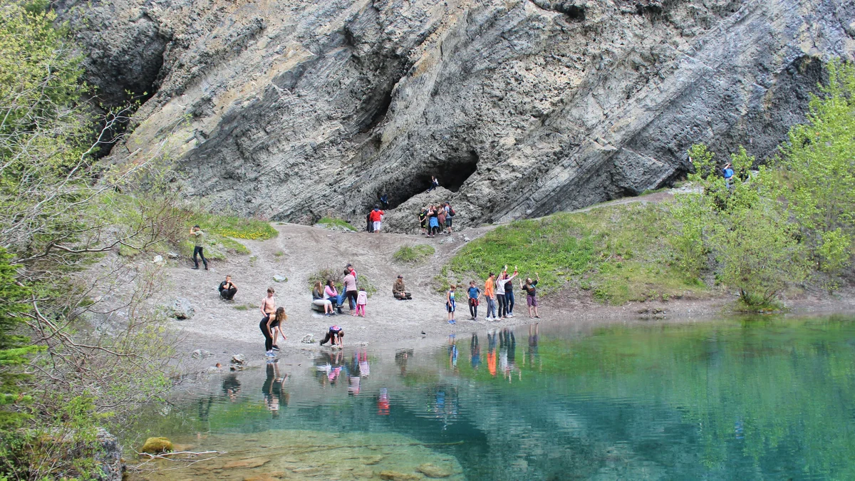
Two strikingly turquoise glacial lakes reached by a popular trail just outside downtown Canmore, named after Lawrence Grassi, an Italian immigrant coal miner who built many of the region's early hiking trails by hand. A moderate uphill walk (or a steeper, rockier route past an old quarry and waterfall) leads to the lower and upper lakes, both fed by underground springs that keep the water a vivid blue-green even in midsummer.
Visitor guide
Grassi Lakes are two small, bright green-blue lakes at about 1,525 metres elevation above Canmore, Alberta. They lie within Canmore Nordic Centre Provincial Park in Kananaskis Country and are named for Lawrence Grassi, the Italian-born miner and trail builder. A short hike from a trailhead near town reaches them, which is why they are among the most visited walks in the Bow Valley.
Born Andrea Lorenzo Grassi on December 20, 1890, in Falmenta, Piedmont, Italy, he emigrated to Canada in 1912 and worked for the Canadian Pacific Railway. He settled in Canmore in 1916 and worked as a coal miner until he retired. In his free time he became a mountaineer and trail builder, constructing hiking trails around Canmore and at Lake O'Hara in Yoho National Park. Several plaques along his trails honour his work, and places named for him include Mount Lawrence Grassi, Grassi Knob and Lawrence Grassi Middle School. He died in Canmore on February 5, 1980, aged 89.
The lakes were once known as the Twin Lakes. One source places the name change in 1938, but the exact date is not consistent across sources, so treat it as approximate. Park signage on the interpretive route tells his story, according to Alberta Parks.
Wikipedia says the lakes' inflow and outflow are linked to the Spray River system and that their water originates at the Spray Lakes Reservoir. The vivid colour is commonly attributed to fine mineral particles suspended in the water that scatter light, as in many mountain lakes, though the sources reviewed here do not give a specific study for Grassi Lakes, so this is a general explanation rather than a measured result.
The lakes sit below grey cliffs about 75 metres (246 feet) high. Wikipedia says these belong to the Cairn Formation, a Late Devonian fossil reef built largely by stromatoporoids, extinct bulbous sponges. Climbers use the pockets left by these sponges as holds, and Alberta Parks notes that the cliffs are regularly visited by climbers.
Alberta Parks says trails that access the climbing routes lead to some unique pictographs, and Wikipedia describes paintings believed to be over 1,000 years old, attributed to ancestors of the Kutenai near the top of the canyon. The attribution is tentative. Rock art is fragile and should never be touched.
Alberta Parks describes two routes from the same trailhead that split about 100 metres along. The easier route, Grassi Lakes Upper, follows an old road through forest. The interpretive route climbs through forest to a steep section with views of a waterfall and the town of Canmore; Alberta Parks lists it as 1.9 kilometres with about 125 metres of elevation gain, while other guides give 3.8 to 4 kilometres for a round trip, so figures vary by route and measure.
Conditions matter. Alberta Parks notes icy, slippery conditions often exist from October to May, and the interpretive route is closed in winter because of ice. The Alberta Parks trail report has also carried closure notices for the area, so always check it before you go. A Kananaskis Conservation Pass is required to park in the area.
Alberta Parks asks visitors to stay on trails, and sources note that swimming is not permitted. A private Voyzo tour with a driver and door-to-door pickup lets your group be dropped at the trailhead and collected after your walk, which avoids the parking squeeze in a busy area. Check Alberta Parks for current access.
See every tour and attraction we cover in Canmore.