TorontoOntario · 36 tours
 Niagara FallsOntario · 25 tours
 New York CityNew York · 30 tours
 Las VegasNevada · 8 tours
 San FranciscoCalifornia · 16 tours
 VancouverBritish Columbia · 17 tours
 DubaiUAE · 54 tours
 Abu DhabiUAE · 5 tours
 Buenos AiresArgentina · 23 tours
 AthensGreece · 31 tours
 AucklandNew Zealand · 38 tours
 CancunMexico · 54 tours
No destinations match “”. Try searching all tours instead — that search understands full questions, not just place names.
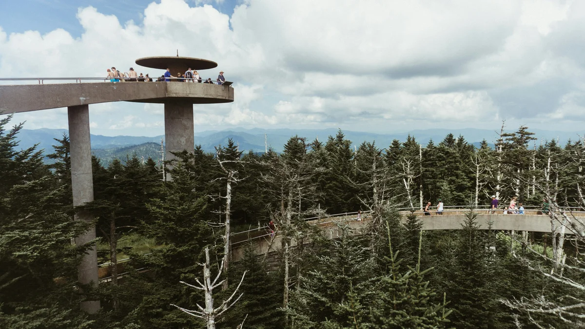
At 6,643 feet, this is the highest point in the Great Smoky Mountains and the third-highest peak east of the Mississippi. A steep half-mile paved path leads to a distinctive spiral observation tower, from which visitors can see up to 100 miles on a clear day, spanning seven states. In 2024 the peak was officially renamed Kuwohi, restoring its traditional Cherokee name.
Visitor guide
Kuwohi, formerly Clingmans Dome, rises 6,643 feet on the Tennessee-North Carolina border and is the highest point in Great Smoky Mountains National Park and in Tennessee. Reached by a seasonal paved road and a short, steep walk to a distinctive concrete observation tower, it is the third-highest summit east of the Mississippi River.
Kuwohi is the Cherokee name, written in syllabary and translated as "mulberry place." The National Park Service describes it as a sacred place, the highest point within the traditional Cherokee homeland, and visible from the Qualla Boundary, home of the Eastern Band of Cherokee Indians. Cherokee tradition also associates the mountain with the White Bear, chief of the bears, and medicine people reportedly came here to pray.
The name Clingmans Dome dates to an 1859 survey by geographer Arnold Guyot, who honored Thomas Lanier Clingman, a North Carolina lawyer, U.S. Representative and Senator, and later a Confederate brigadier general. The renaming effort began in 2022, led by enrolled tribal members Lavita Hill and Mary Crowe. Principal Chief Michell Hicks submitted the request in January 2024, and the U.S. Board on Geographic Names approved it on September 18, 2024. The park closes the peak for three half days each year so predominantly Cherokee schools can visit and learn its history from elders and language speakers.
The observation tower is a 45-foot concrete structure completed on October 23, 1959, designed by Hubert Bebb in a modern style that departed from the rustic look of earlier park buildings. A spiral ramp climbs to a 360-degree platform. It was one of nine towers built under the Mission 66 program and was listed on the National Register of Historic Places in 2012.
The National Park Service puts the walk from the parking area to the tower at about one mile round trip, short but steep and paved. The Appalachian Trail passes just north of the tower, and a bypass trail from the Forney Ridge Trailhead offers a quieter route toward the AT. The summit is covered in southern Appalachian spruce-fir forest, a high-elevation habitat found only on the tallest Southeast peaks, where many Fraser firs have been killed by the non-native balsam woolly adelgid. Summit weather can differ a great deal from conditions in the valleys.
Kuwohi Road, formerly Clingmans Dome Road, is seasonal. The park notes that parking is limited and a parking tag is required, and it suggests considering a shuttle or an alternative if the lot is full. Check the National Park Service for current road status, parking and permits. The park reports more than 650,000 visitors a year at the peak.
Voyzo runs this as a private tour, with your own vehicle and driver and door-to-door pickup, so you can set the pace and spend as long as you like at each stop. A driver also takes the stress out of the parking question on a busy mountain road.
See every tour and attraction we cover in Great Smoky Mountains National Park.