TorontoOntario · 36 tours
 Niagara FallsOntario · 25 tours
 New York CityNew York · 30 tours
 Las VegasNevada · 8 tours
 San FranciscoCalifornia · 16 tours
 VancouverBritish Columbia · 17 tours
 DubaiUAE · 54 tours
 Abu DhabiUAE · 5 tours
 Buenos AiresArgentina · 23 tours
 AthensGreece · 31 tours
 AucklandNew Zealand · 38 tours
 CancunMexico · 54 tours
No destinations match “”. Try searching all tours instead — that search understands full questions, not just place names.
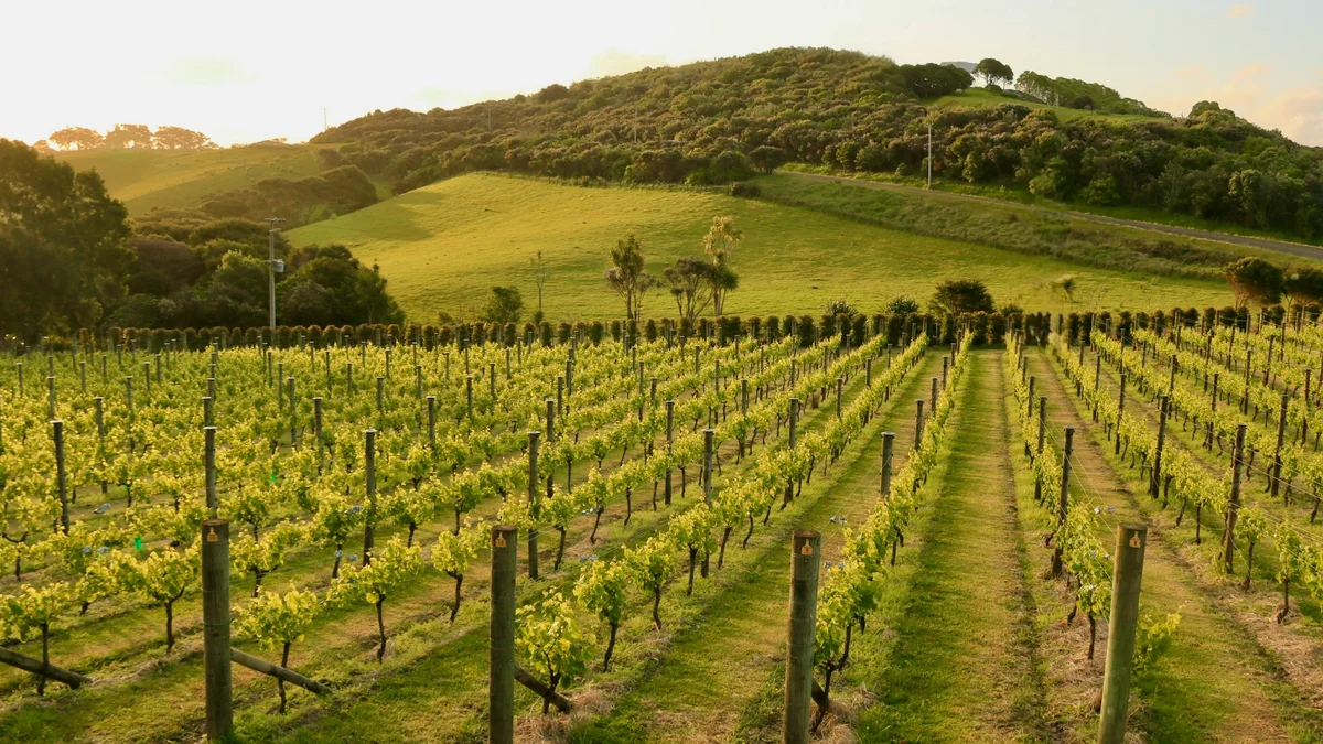
Waiheke Island sits about a 40-minute ferry ride from downtown Auckland in the Hauraki Gulf, and has grown from a quiet rural retreat into one of New Zealand's best-known wine destinations. Its warm, dry microclimate suits Bordeaux-style reds and rosé especially well, and more than two dozen boutique vineyards and olive groves are spread across its rolling hills. Beyond the wineries, the island has sheltered swimming beaches and coastal walking tracks, making it a popular full-day trip from the city.
Visitor guide
Waiheke Island is the second-largest island in the Hauraki Gulf, a short ferry ride from central Auckland in New Zealand's North Island. Known as an island of wine, it combines vineyards, sheltered beaches, native bush and a long Maori and colonial history.
According to Wikipedia, Waiheke covers about 92 square kilometres and is roughly 19 km long from west to east. It has about 133 km of coastline, including some 40 km of beaches, and is very hilly with few flat areas; the highest point is Maunganui at 231 metres. The Matiatia ferry terminal at the western end is about 21.5 km from Auckland's central-city terminal. The island is the most accessible in the gulf and had an estimated 9,310 permanent residents in June 2025. Its original Maori name is reported as Te Motu-arai-roa, the long sheltering island, and the name Motu-Wai-Heke, island of trickling waters, was in use when Europeans arrived.
Hauraki Gulf islands were settled in the archaic period of Maori history, and Waiheke was one of only two large islands, with Great Barrier, to sustain permanent settlement. Ngati Paoa and Ngati Maru are the main tribes associated with it. The island was briefly depopulated during the Musket Wars. A shipyard opened at Man o'War Bay in 1836, followed by forestry, timber and manganese mining, and shipping services from the 1880s helped establish it as a seaside resort. Electricity arrived in 1953, and gun emplacements built at Stony Batter in World War II were never fired in combat.
Wikipedia lists a range of beaches. Oneroa is the main beach, Onetangi is a 1.87 km north-facing stretch whose name is often translated as weeping sands, Palm Beach is named for its mature phoenix palms, and Shelly Beach is sheltered and suited to families. Cactus Bay can be reached only by boat or kayak. Waiheke has a subtropical climate with warm, humid summers and mild winters, and NIWA data suggest it receives more than 100 extra hours of sunshine a year compared with other parts of Auckland.
Native birds including kereru, tui, weka and kaka live on the island, and godwits, oystercatchers and little penguins use the shorelines and wetlands. Whakanewha Regional Park and the Onetangi Reserve are notable natural areas.
Waiheke is known as New Zealand's island of wine. The warm climate suits Bordeaux-style grapes, and Syrah from the island has won international awards. Wikipedia notes that Goldwater Estate was among the first winemaking operations, that Stonyridge was founded in 1981, and that Kennedy Point has been certified organic since 1996.
The island also hosts Sculpture on the Gulf, a biennial outdoor sculpture exhibition along a coastal walkway that drew more than 30,000 visitors in 2013, plus a community cinema, a theatre and many privately run galleries. A private guided day trip suits the island's spread-out wineries and beaches, with the ferry from Auckland as the usual starting point.
See every tour and attraction we cover in Auckland.