TorontoOntario · 36 tours
 Niagara FallsOntario · 25 tours
 New York CityNew York · 30 tours
 Las VegasNevada · 8 tours
 San FranciscoCalifornia · 16 tours
 VancouverBritish Columbia · 17 tours
 DubaiUAE · 54 tours
 Abu DhabiUAE · 5 tours
 Buenos AiresArgentina · 23 tours
 AthensGreece · 31 tours
 AucklandNew Zealand · 38 tours
 CancunMexico · 54 tours
No destinations match “”. Try searching all tours instead — that search understands full questions, not just place names.
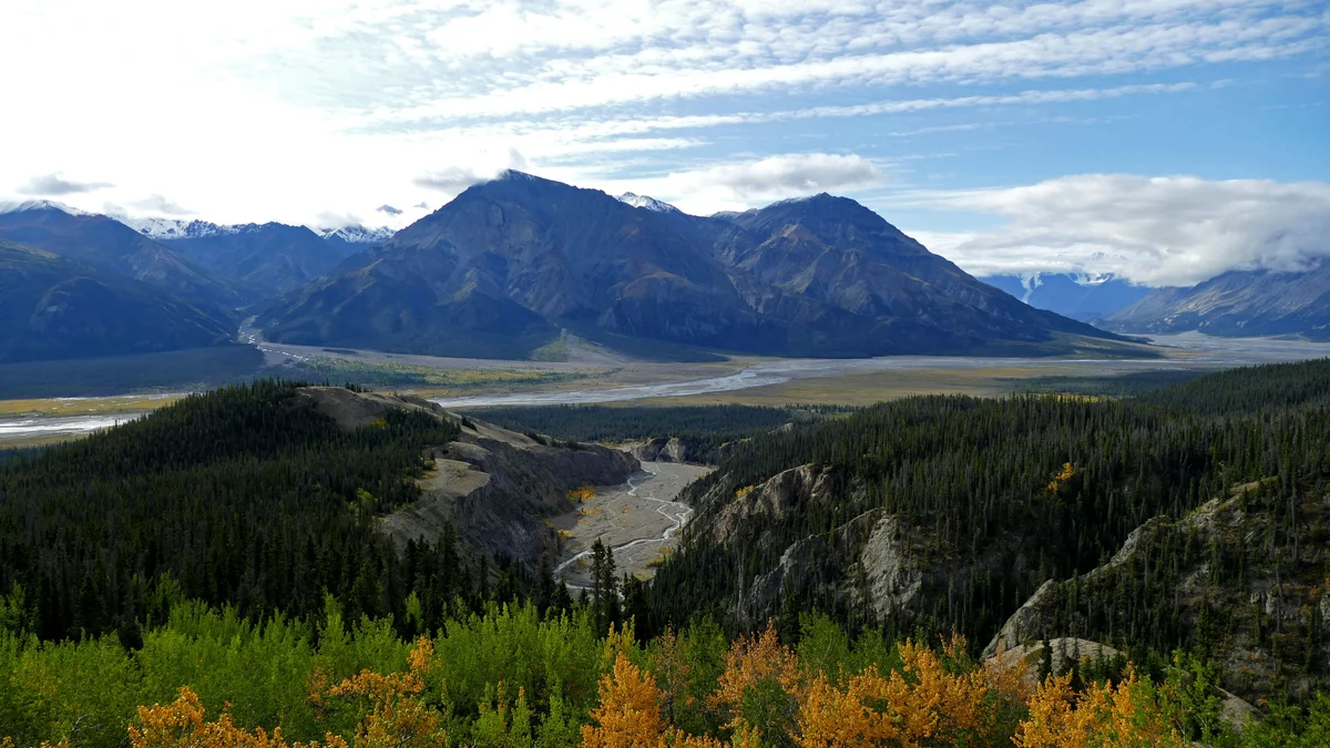
A UNESCO World Heritage park about 2.5 hours from Whitehorse, home to Canada's tallest mountains and largest non-polar ice fields.
Visitor guide
Kluane National Park and Reserve occupies the southwestern corner of Yukon, roughly 160 kilometres west of Whitehorse by Parks Canada's figure. It protects Canada's highest mountain, Mount Logan, and vast glaciers in the Saint Elias Mountains, and forms part of a transboundary UNESCO World Heritage Site.
The area was first set aside by the federal government in 1943 as a game sanctuary to protect wildlife, and part of that Kluane Game Sanctuary later became the park and reserve. The reserve was designated in 1976 according to Parks Canada (some sources give 1972 for the area first set aside), pending the settlement of First Nations land claims, and its eastern portion of about 5,900 square kilometres became a national park on 29 May 1993 after agreement with the Champagne and Aishihik First Nations. The full park and reserve together cover about 22,013 square kilometres, and the larger western section remains a reserve. Kluane lies within the traditional territories of the Champagne and Aishihik First Nations and the Kluane First Nation, whose final agreements give legal force to their harvesting rights, and it is cooperatively managed with Parks Canada. Parks Canada describes the region as part of the Southern Tutchone people's traditional territory, where the Dän lived by hunting and gathering over thousands of years.
Mountains and glaciers cover about 83 per cent of the park, including the Donjek Glacier. East of the largest peaks and ice fields the land is colder and drier, with forest and tundra; trees grow only at the lowest elevations, mainly white spruce, balsam poplar and trembling aspen. Alpine meadows and clear lakes complete the picture. Descriptions of the park as home to the largest non-polar ice fields are common, but sources vary on wording, so treat superlatives with care.
Mount Logan rises to 5,959 metres (19,551 feet). Its height was fixed in 1992 by a Geological Survey of Canada expedition using GPS; earlier estimates ranged from about 5,959 to 6,050 metres. The mountain is named for Sir William Logan, founder of the Geological Survey of Canada, and American geologist Israel Russell is credited with naming it after reporting it in 1890. The first ascent came on 23 June 1925, when a party led by Albert MacCarthy, with H. F. Lambart, Allen Carpe, Norman Read, W. W. Foster and Andy Taylor, reached the summit after an expedition of about 65 days from McCarthy, Alaska. Wikipedia reports that the massif is still being pushed up by tectonic uplift at roughly a third of a millimetre a year and describes it as having eleven peaks above 5,000 metres. On its high plateau, winter air temperatures are reported to hover around minus 45 degrees Celsius, and an ice cap almost 300 metres thick has built up in places.
Valley glaciers such as the Kaskawulsh, which Wikipedia gives as about 78 kilometres long, are major features and are retreating. Until 2016 the glacier's meltwater flowed through the Slims River to Kluane Lake and onward toward the Bering Sea. As the ice receded, the main flow switched to the Kaskawulsh River, which runs east and then south to the Alsek River and the Gulf of Alaska. Researchers published the finding as a rare, rapid example of river capture, in a paper in Nature Geoscience in 2017. The change lowered water levels in Kluane Lake and affects the Slims River valley.
Scientific interest in the region goes back to the 1930s, when Walter Wood and Bradford Washburn led separate Yukon expeditions in 1935. Wood's 1948 Project Snow Cornice was the first expedition to make glacier science its main focus. His Icefield Ranges Research Project led the Arctic Institute of North America to establish the Kluane Lake Research Station on the south shore of the lake in 1961, and a history of Yukon glacier studies says virtually all later field studies of Yukon glaciers were launched from that base.
UNESCO inscribed the site in 1979, with extensions in 1992 and 1994, as the bi-national Kluane / Wrangell-St. Elias / Glacier Bay / Tatshenshini-Alsek site. It is recognised for its glaciers and icefields, geology, ecosystems and wildlife habitat.
The park supports grizzly bears, Dall sheep, mountain goats, caribou, moose, wolves, lynx and wolverine, plus about 120 bird species including golden and bald eagles and rock ptarmigan. A 2009 census counted 181 northern mountain caribou in the Kluane herd. Parks Canada provides bear-safety guidance, and wildlife is best viewed from a distance.
Kathleen Lake is the most accessible part of the park, with a day-use area, a boat launch, a campground and the King's Throne hike; other named trails include St. Elias Lake, Rock Glacier and Soldiers Summit. The Alsek River, a Canadian Heritage River, is used for rafting. Parks Canada operates a Haines Junction Visitor Centre and a Thechal Dhal Visitor Centre with seasonal hours, so check the Parks Canada website for current dates, fees and conditions. Much of the interior is reachable only by experienced backcountry travellers or by flightseeing from Haines Junction.
Haines Junction is the nearest community and the park's gateway.
See every tour and attraction we cover in Whitehorse.