TorontoOntario · 36 tours
 Niagara FallsOntario · 25 tours
 New York CityNew York · 30 tours
 Las VegasNevada · 8 tours
 San FranciscoCalifornia · 16 tours
 VancouverBritish Columbia · 17 tours
 DubaiUAE · 54 tours
 Abu DhabiUAE · 5 tours
 Buenos AiresArgentina · 23 tours
 AthensGreece · 31 tours
 AucklandNew Zealand · 38 tours
 CancunMexico · 54 tours
No destinations match “”. Try searching all tours instead — that search understands full questions, not just place names.
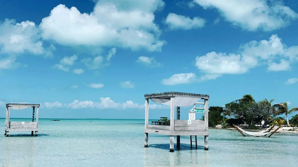
A shallow, calm stretch of water on the western, leeward side of Ambergris Caye, facing the mainland rather than the open Caribbean. Once a genuinely little-known local spot, it's grown into one of the island's most popular casual hangouts, lined with small beach bars built out over the water on stilts, known for calm swimming conditions rather than reef snorkeling.
Visitor guide
Secret Beach is a stretch of shallow, calm water on the western, leeward side of Ambergris Caye in Belize, facing the mainland lagoon rather than the open Caribbean. Wikipedia describes it as lying north of San Pedro Town and calls it 'San Pedro's worst kept secret', reflecting how popular it has become with both visitors and locals.
Most of Ambergris Caye's tourism is oriented toward the east, where the Belize Barrier Reef runs parallel to the shore. Secret Beach is on the opposite, sheltered coast, so the water is protected from open-sea swells. Accounts describe bright blue, very shallow water that allows people to wade out a long way from shore, which makes it a place for relaxed swimming and floating rather than reef snorkeling. Wikipedia also mentions cenotes, sinkholes and caves in the surrounding area, though these are not the main draw.
The island itself is long and narrow, roughly 40 kilometres from north to south and about 1.6 kilometres wide, with mangrove forest in its center and pale coral sand along much of its coast. Wikipedia notes that most of the island is reserved as national park or wildlife preserve, which limits development, and that the area around Secret Beach has seen relatively little substantial development, giving it a more remote feel.
Sources differ on exactly how the beach became easy to reach. One account says that a developer built the first road from the eastern to the western side of the island roughly a decade ago, while another says a bridge connecting the two sides was what changed access. Both agree that it was once reachable mostly by boat and is now reachable by golf cart or taxi along the island's northern road. The exact timeline should therefore be treated as unsettled. Wikivoyage mentions a bridge north of San Pedro that carries the road toward the north of the island.
One promotional source says the beach started as a small family-run operation, growing from a cooler and grill into a bustling beach area; since that source is a real estate marketing site, it is best treated with caution.
San Pedro Town, the island's only town, grew from a settlement established around 1848 and 1849 by refugees from the Caste War of Yucatan, and today relies heavily on tourism and diving. Golf carts are the main way of getting around the island, and the north road stretches over ten miles beyond town with resort and beach house development, according to Wikipedia.
Secret Beach sits within a wider area of the island that includes Hol Chan Marine Reserve and Shark Ray Alley to the south, Mexico Rocks off the northeast coast, and Bacalar Chico National Park and Marine Reserve near the Mexican border to the north.
Secret Beach is best understood as a calm-water social spot rather than a reef or wildlife destination. Conditions depend on wind and weather, and the shallows can be affected by tides and seasonal changes. A private tour with a driver can combine it with other stops across the island and spare visitors from navigating the unpaved north road themselves.
See every tour and attraction we cover in San Pedro, Belize.