TorontoOntario · 36 tours
 Niagara FallsOntario · 25 tours
 New York CityNew York · 30 tours
 Las VegasNevada · 8 tours
 San FranciscoCalifornia · 16 tours
 VancouverBritish Columbia · 17 tours
 DubaiUAE · 54 tours
 Abu DhabiUAE · 5 tours
 Buenos AiresArgentina · 23 tours
 AthensGreece · 31 tours
 AucklandNew Zealand · 38 tours
 CancunMexico · 54 tours
No destinations match “”. Try searching all tours instead — that search understands full questions, not just place names.
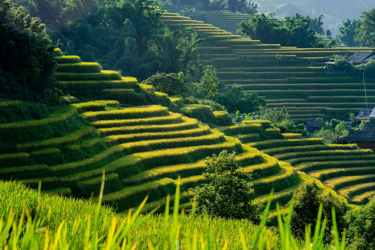
Steep, centuries-old terraced rice fields in Vietnam's northern mountains near the town of Sapa, home to H'mong and other ethnic minority communities.
Visitor guide
Sapa's rice terraces are steep, hand-built fields stepped into the mountainsides of the Hoang Lien Son range in Lao Cai province, northern Vietnam. The best-known system lies in the Muong Hoa valley near the highland town of Sa Pa, where ethnic minority communities have farmed the slopes for generations.
According to Wikipedia, Sa Pa lies on the Lo Suoi Tung plateau within the Hoang Lien Son range, about 300 kilometres northwest of Hanoi and close to the Chinese border. Mount Fansipan, Vietnam's highest peak, rises about nine kilometres to the southwest. The terrain is steep and deeply cut by valleys, with slopes over 25 degrees covering roughly 80 percent of Lao Cai province, which is exactly why farmers sculpted terraces to grow rice. French colonists developed Sa Pa as a hill resort to escape lowland heat, building European-style hotels and villas, and the stone Sapa Church dates from 1925.
The most famous terraced area is usually described as the Ta Van, Hau Thao and Lao Chai field system in the Muong Hoa stream valley, roughly ten kilometres from the town. Travel sources give widely varying area figures, from nearly 1,000 hectares to over 4,000, so those numbers are best treated as approximate. In 2013, according to one source, Vietnam's culture ministry recognised the Sapa terraced fields as a National Landscape Relic covering over 749 hectares. Lao Chai is described as a Black H'mong village, and the valley is also home to Dao, Giay and Tay communities. Sources say the terraces were created by these groups hundreds of years ago, and a figure of 500 years appears in travel writing, though it is not a documented date.
The highland climate is cool, with average temperatures of around 15 to 16 degrees Celsius, and the cold, dry winters limit farming to a single rice crop a year. Rain falls mostly from April to September, bringing 70 to 80 percent of the annual total. Travel guides generally describe the cycle this way: fields are flooded and ploughed around May and June, seedlings turn the slopes green in the early summer, the rice ripens to gold in late summer, and harvest runs around September and October. Exact timing varies by year and by altitude, so it is wise to ask a local guide about conditions.
Tourism to Sa Pa resumed after Vietnam's market reforms, with Wikipedia noting a return of visitors from 1991. The terraces are best understood through the villages around them, where a local guide can explain how irrigation, buffalo ploughing and family labour keep the slopes productive. A private vehicle and driver makes the winding mountain road from Lao Cai or Hanoi simpler to manage, and a guide can adapt a visit to the weather and the stage of the rice crop.
See every tour and attraction we cover in Vietnam.