TorontoOntario · 36 tours
 Niagara FallsOntario · 25 tours
 New York CityNew York · 30 tours
 Las VegasNevada · 8 tours
 San FranciscoCalifornia · 16 tours
 VancouverBritish Columbia · 17 tours
 DubaiUAE · 54 tours
 Abu DhabiUAE · 5 tours
 Buenos AiresArgentina · 23 tours
 AthensGreece · 31 tours
 AucklandNew Zealand · 38 tours
 CancunMexico · 54 tours
No destinations match “”. Try searching all tours instead — that search understands full questions, not just place names.
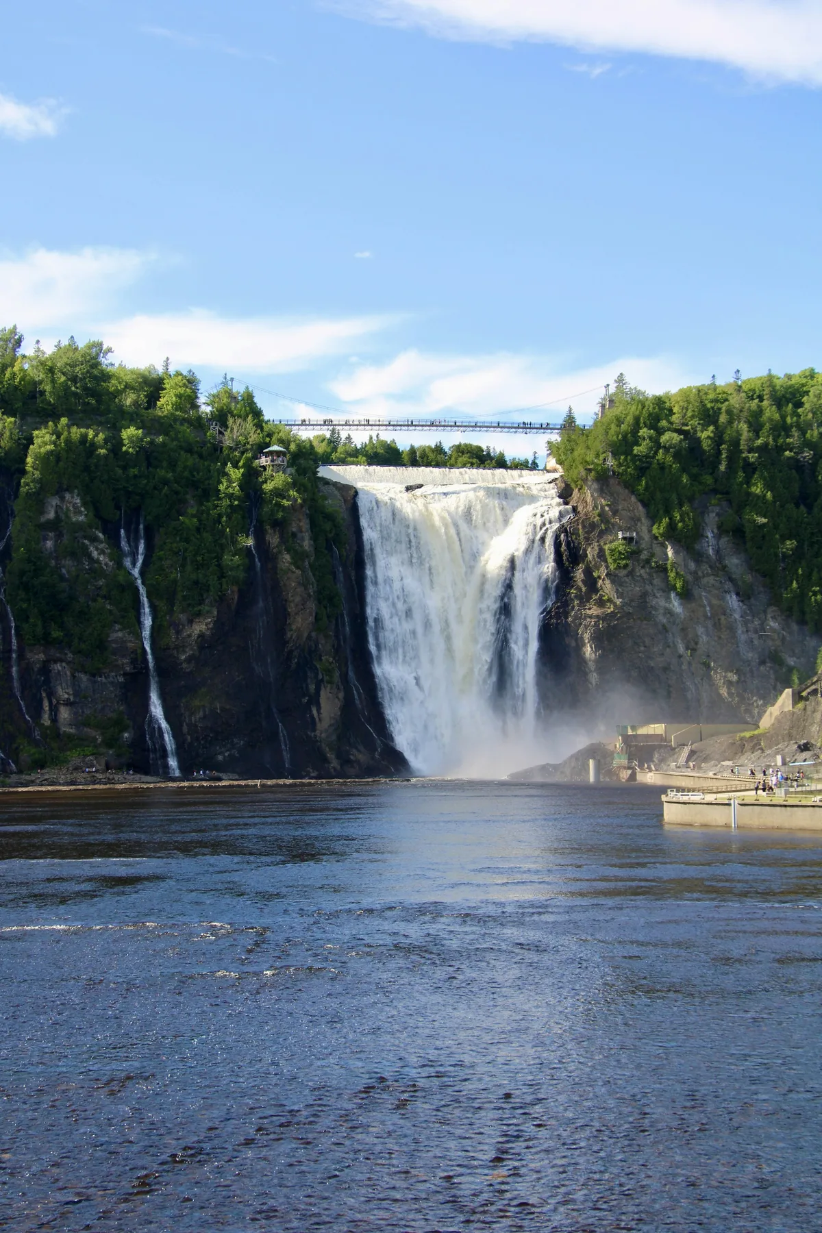
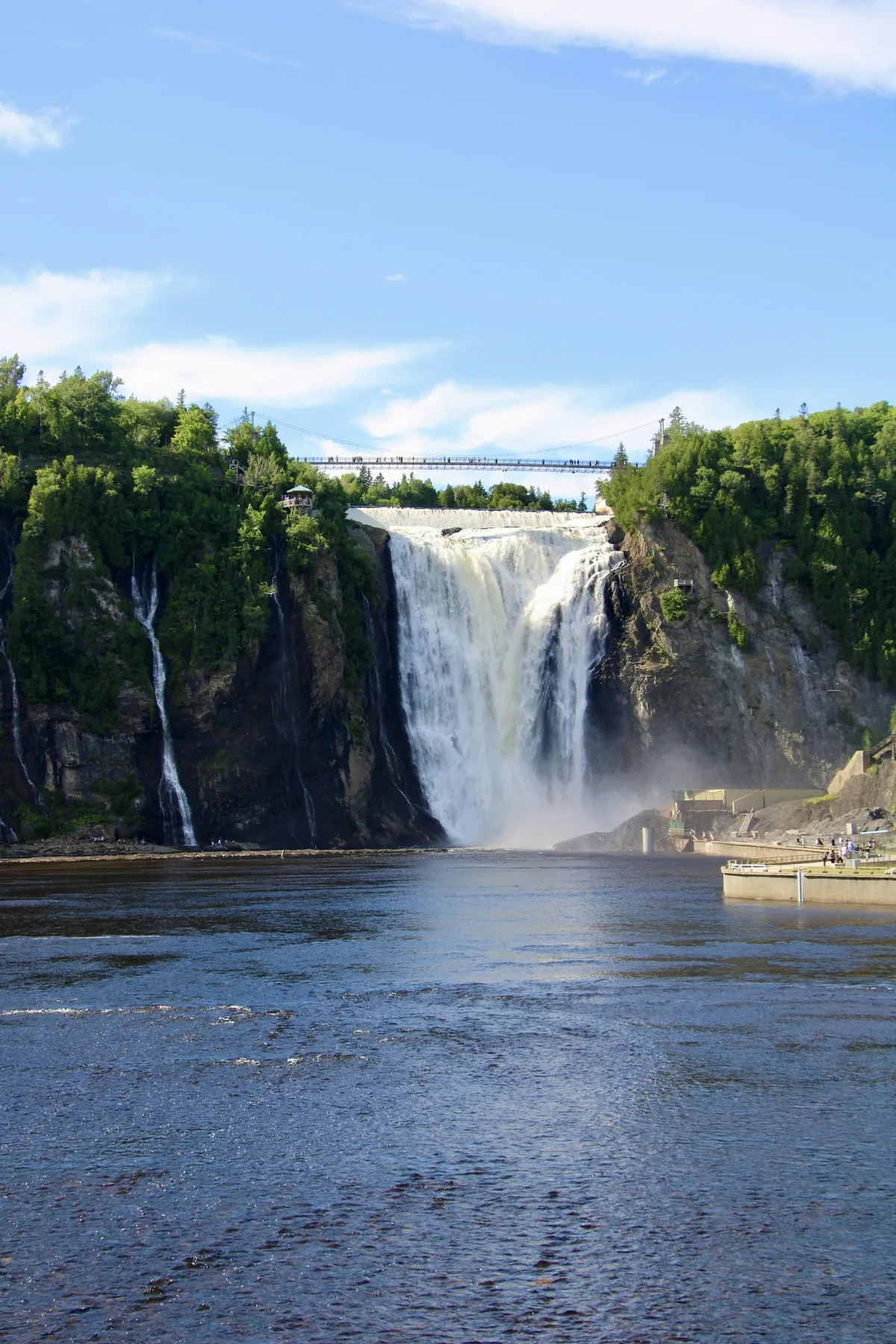
An 83-metre waterfall about 30 minutes from Old Québec — taller than Niagara Falls — crossed by a footbridge at its crest.
Visitor guide
Montmorency Falls plunges about 83 metres (272 feet) from the Montmorency River into the St. Lawrence, on the edge of Québec City's Beauport district. Sources give the drop as 83 or 84 metres, and describe it as roughly 30 metres higher than Niagara Falls, though much narrower and carrying far less water. It is generally described as the highest waterfall in Québec and, per the Canadian Encyclopedia, the eighth highest in Canada.
The Montmorency River rises in the Laurentides wildlife reserve north of Québec City and runs roughly 100 kilometres to the St. Lawrence. Sources differ slightly on when the falls were named: the Canadian Encyclopedia says Samuel de Champlain named them in 1608 for Henri II, duc de Montmorency, later viceroy of New France (1620 to 1625), and notes that a pilot on Roberval's 1542 expedition had already recorded the cascade. Some popular accounts give a later date, so treat the exact year as approximate.
The falls also sit on a battlefield. In July 1759, during the British campaign against Québec, General James Wolfe's forces landed near the base and fortified a camp on the heights to the east. The Battle of Montmorency on 31 July 1759 ended with the British repulsed by French troops and withdrawing, two months before the decisive Battle of the Plains of Abraham. Artists kept coming afterward; Wikipedia records a drawing made from the British camp that July and a 1781 etching, and the falls are even mentioned in an 1816 poem by John Keats.
Power generation has long been part of the story too: the Canadian Encyclopedia notes that hydroelectric developments at the waterfall supply electricity to Québec City.
In cold weather, spray builds an ice mound at the foot of the falls known as the "sugarloaf" (pain de sucre), often cited at 30 metres or more in height. Sliding down it was a popular pastime in the 19th century, and nineteenth-century paintings by Robert Clow Todd and Joseph Légaré show the cone. The falls remain visible in winter, but the shape and size of the cone vary with the weather.
The falls are protected inside Parc de la Chute-Montmorency, managed by Sépaq. A suspended footbridge crosses the crest to a belvedere above the drop, a panoramic staircase of 487 steps descends the cliff beside the falls (a staircase from base to crest was first added in 1993, according to the Canadian Encyclopedia), and a cable car runs between the base and the clifftop manor. The manor houses an interpretation centre, a gift shop and a terrace restaurant. There is also a historical orchard, three via ferrata routes and a 300-metre zipline over the plunge pool, per Québec City's tourism office. In summer the water can look faintly yellow, which Wikipedia attributes to iron in the riverbed.
Wikipedia reports roughly 970,000 visitors a year and notes that the Ice Hotel was located at the falls in its first year, 2001. A summer fireworks competition has used the falls as its backdrop, the site appeared in the 1947 film Whispering City, and a C$33-million upgrade of the site was announced in July 2019. The Montmorency itself flows over two drops and averages about 130 cubic metres per second, which is why the falls read as tall and slender rather than broad. Wikipedia places them on the boundary of Beauport and Boischatel, opposite the western end of Île d'Orléans. The park also offers guided history tours and a mobile restaurant themed on 1759, according to the city tourism office.
See every tour and attraction we cover in Quebec City.