TorontoOntario · 36 tours
 Niagara FallsOntario · 25 tours
 New York CityNew York · 30 tours
 Las VegasNevada · 8 tours
 San FranciscoCalifornia · 16 tours
 VancouverBritish Columbia · 17 tours
 DubaiUAE · 54 tours
 Abu DhabiUAE · 5 tours
 Buenos AiresArgentina · 23 tours
 AthensGreece · 31 tours
 AucklandNew Zealand · 38 tours
 CancunMexico · 54 tours
No destinations match “”. Try searching all tours instead — that search understands full questions, not just place names.
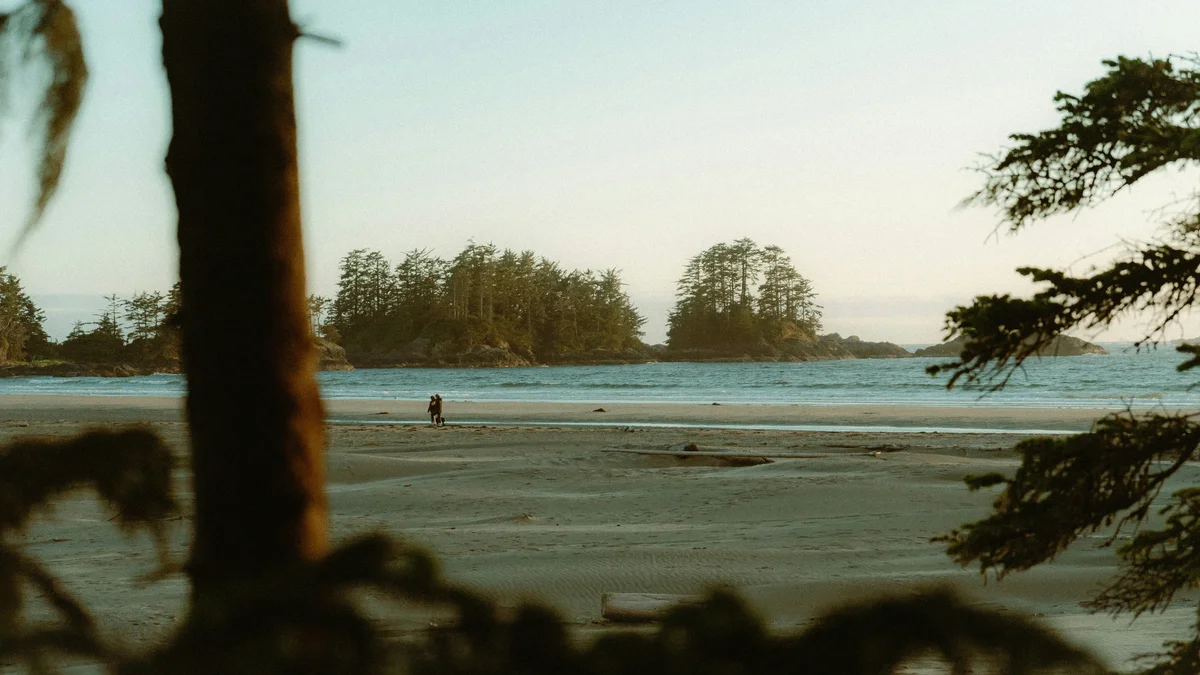
One of Tofino's most photographed beaches, Chesterman Beach is a genuine local and visitor favourite split into north and south halves by Frank Island, which becomes a walkable sandbar at low tide. It's a real, active surf beach with tide pools exposed at low tide, and it's the beach most Tofino surf schools use for lessons.
Visitor guide
Chesterman Beach is a sandy stretch just south of Tofino on the west coast of Vancouver Island, British Columbia, roughly 2.7 kilometres long (sources range from about 2.5 to 3 kilometres). A sandspit called a tombolo divides it into North and South Chesterman and leads at low tide to Frank Island.
A pine forest sits behind the sand. At low tide the rock pools can hold crabs and starfish, and in spring and summer migrating whales are sometimes seen offshore.
The English name honours an early settler, but sources disagree on which Chesterman. The BC Geographical Names record, which says Parks Canada literature used the name by 1966 and that it was officially adopted on 14 July 1975, cites two possible namesakes: Charles Allan Chesterman (1908-1968), a lifelong local resident, and John Chesterman, who arrived soon after 1900, farmed where the Long Beach airport now stands and later served as coxswain of the lifeboat. The Encyclopedia of Raincoast Place Names describes John Phillip Chesterman (1867-1913) as a holder of Crown land grants on the Esowista Peninsula, opposite the beach, in 1900 and 1912; the same entry says he and his wife farmed and that he was coxswain of the Tofino lifeboat.
The same provincial record lists the Tla-o-qui-aht name n̓an̓aquuʔa, meaning needlefish, for the north beach, though it is not an official name. The south beach has its own distinct Tla-o-qui-aht name, based on information the First Nation gave in 2025. The Tla-o-qui-aht are one of the Nuu-chah-nulth peoples, and long before the town grew they lived on and harvested these shores. Tofino itself sits in their traditional territory, which includes the Esowista Peninsula, Tofino Inlet and Meares Island.
A tombolo is a sand bar that ties an island to the shore. At Chesterman it appears at low tide so walkers can cross to Frank Island, sometimes called Middle Chesterman, for views back along the beach. The tide returns, so check tide times and leave in good time to avoid being cut off.
Tofino was reachable only by air, water or a gated logging road until a highway link opened in August 1959, and the road was fully paved in 1972. Surfing culture took root from the mid-1960s, and tourism overtook fishing and logging as the main local industry from the 1990s. The Wickaninnish Inn opened on Chesterman Beach in 1996, followed by other lodges along this coast. Tofino was granted resort municipality status in 2008. Chesterman is a common place to learn because it is the closest surf break to town, with schools operating from it.
Rip currents can be strong. The Wickaninnish Inn notes there are no lifeguards and recommends a lesson.
The Guardian placed the beach 33rd on its 2016 list of the world's top 50 beaches. The Wickaninnish Inn reports that Lonely Planet ranked it sixth-best in the world and describes it as the only temperate beach in that top ten; the Inn's own press release is dated February 2024, and the claim comes from a local operator, so confirm it independently.
The Guardian's write-up notes that orcas may be seen beyond the breakers, and the beach has family-friendly tidepools. Tofino has a marine west coast climate and records roughly 3,270 millimetres of precipitation a year at its airport station, far more than Victoria, and winter cyclonic storms are why the town is well known for storm-watching. Conditions can be hazardous near driftwood and the shoreline when surf is heavy.
Long Beach in Pacific Rim National Park Reserve lies a short drive south, with Tofino to the north. A private tour with Voyzo, a private vehicle with a driver and door-to-door pickup, lets you fit beach time around tides without managing parking at busy access points.
See every tour and attraction we cover in Vancouver Island.