TorontoOntario · 36 tours
 Niagara FallsOntario · 25 tours
 New York CityNew York · 30 tours
 Las VegasNevada · 8 tours
 San FranciscoCalifornia · 16 tours
 VancouverBritish Columbia · 17 tours
 DubaiUAE · 54 tours
 Abu DhabiUAE · 5 tours
 Buenos AiresArgentina · 23 tours
 AthensGreece · 31 tours
 AucklandNew Zealand · 38 tours
 CancunMexico · 54 tours
No destinations match “”. Try searching all tours instead — that search understands full questions, not just place names.
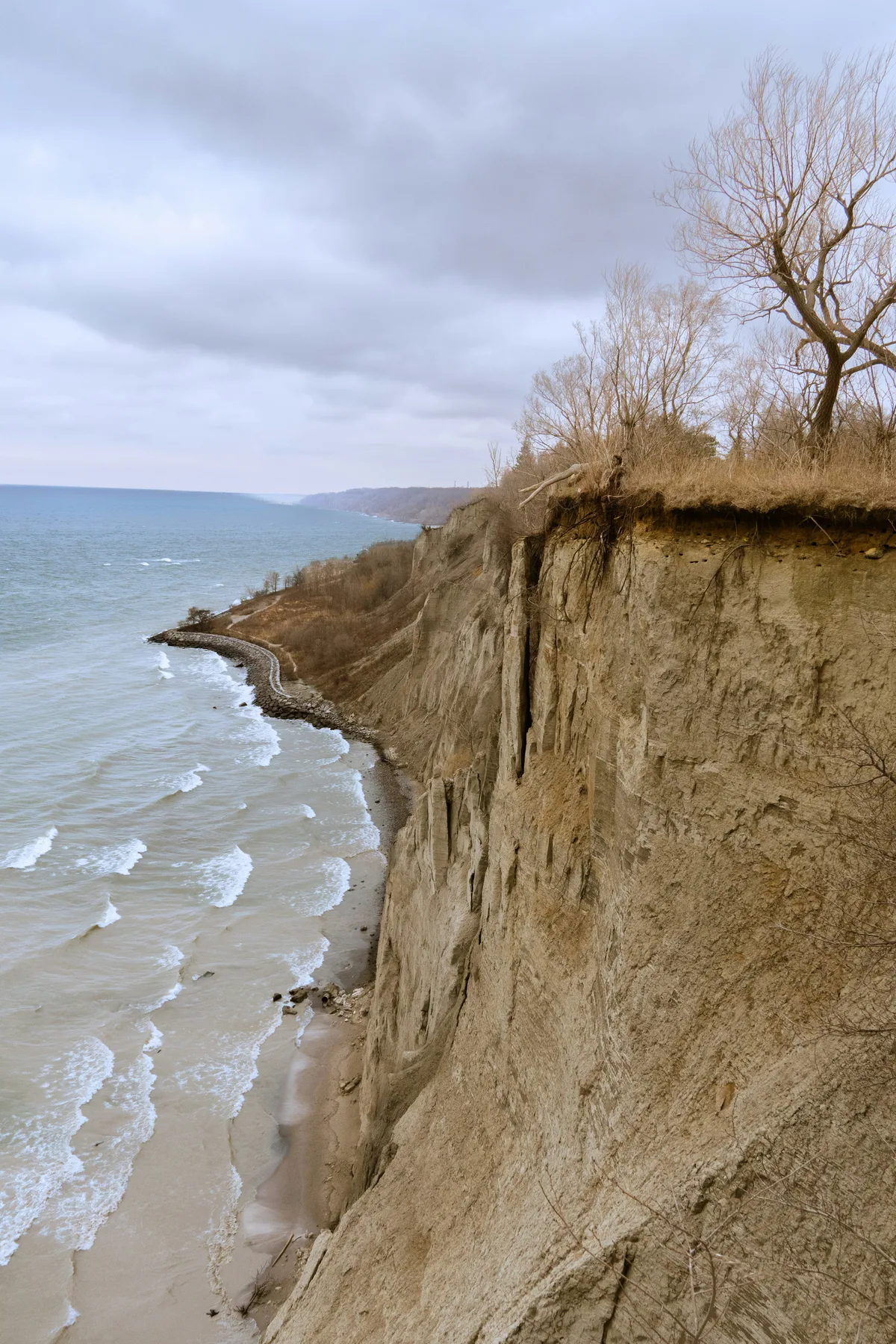
Sheer, eroded sand-and-clay cliffs rising up to 90 meters above Lake Ontario on Toronto's eastern edge, with parkland and beaches at their base and sweeping lake views from the top.
Visitor guide
The Scarborough Bluffs are a long escarpment of layered sand and clay along Lake Ontario in Toronto's east end, running about 15 kilometres from the foot of Victoria Park Avenue to the mouth of Highland Creek. At their highest they rise about 90 metres (300 feet) above the lake.
The cliffs expose layers of sediment laid down during the last ice age and the interglacial period before it. Geologists describe a thick deltaic deposit known as the Scarborough Formation, capped by glacial material such as the Sunnybrook Till, though sources disagree on exact ages and how the till formed; figures from roughly 45,000 to over 100,000 years are quoted in different studies, so treat any single number with care. The Bluffs and the Don Valley Brickworks are regarded as important records of glacial history in the Toronto area. The escarpment is part of the old shoreline of Glacial Lake Iroquois, and eroded material from the Bluffs is thought to have contributed to the Toronto Islands.
French mapmakers reportedly called the cliffs Les Grands Ecores, and an early plan from 1788 labelled them the High Lands. In 1793 Elizabeth Simcoe, wife of Lieutenant Governor John Graves Simcoe, named them the Scarborough Highlands, reminded of the cliffs at Scarborough in North Yorkshire. The name was extended to the whole township in 1796. The western end of the escarpment was levelled in the past for development.
The Bluffs erode constantly through wind, rain, groundwater and waves. Erosion has accelerated since houses were built along the bluff tops, a real-estate boom that began around the 1940s. A cottage hung over the edge in 2008 and a large section collapsed near Lookout Point in August 2020, with no injuries reported. The Toronto and Region Conservation Authority, in partnership with the City of Toronto, undertook the Scarborough Waterfront Project, whose environmental assessment received final approval in 2019; TRCA describes it as enhanced shoreline protection, greenspace and habitat work along an 11-kilometre shoreline trail between Bluffer's Park and East Point Park. Restricted areas carry fines, so stay on marked paths and well away from the cliff edge and base.
Around eleven parks run along the Bluffs. Bluffer's Park, which opened in 1975, is the only one with a beach and has a marina, boat launch and a view of the cliff face. Cathedral Bluffs Park and Scarboro Crescent Park offer clifftop lookouts, and Rosetta McClain Gardens is a landscaped garden near the edge.
Guild Park and Gardens, on the bluffs at Guildwood Parkway, grew from an artists' colony and inn that Rosa Hewetson and Spencer Clark began in 1932. The Clarks salvaged stonework from demolished Toronto buildings, and remnants from more than 60 buildings now stand in the gardens, including a Greek Theatre built from pieces of the old Bank of Toronto. The park is operated by Toronto Parks on Toronto and Region Conservation Authority land; check the City for current access.
Kingston Road, the Scarborough Heights area and the Guildwood neighbourhood are close, and the Toronto Zoo and Rouge National Urban Park lie further east.
See every tour and attraction we cover in Toronto.