TorontoOntario · 36 tours
 Niagara FallsOntario · 25 tours
 New York CityNew York · 30 tours
 Las VegasNevada · 8 tours
 San FranciscoCalifornia · 16 tours
 VancouverBritish Columbia · 17 tours
 DubaiUAE · 54 tours
 Abu DhabiUAE · 5 tours
 Buenos AiresArgentina · 23 tours
 AthensGreece · 31 tours
 AucklandNew Zealand · 38 tours
 CancunMexico · 54 tours
No destinations match “”. Try searching all tours instead — that search understands full questions, not just place names.
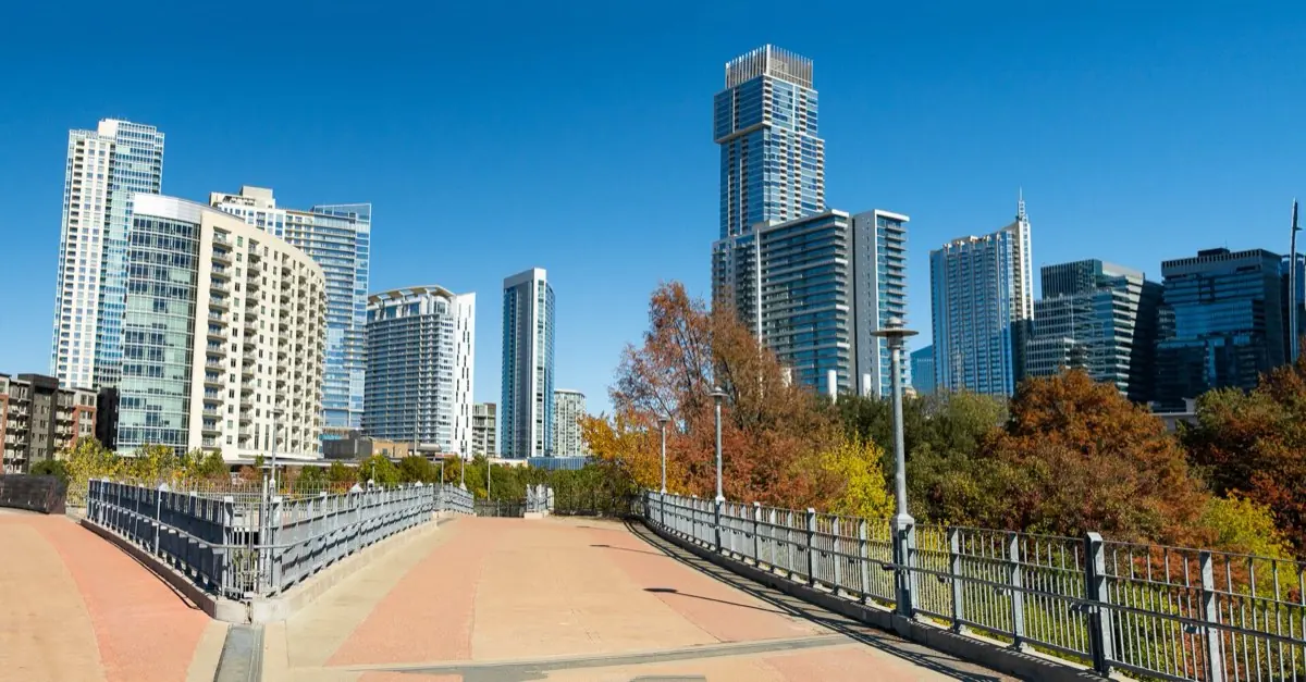
A pedestrian bridge connecting downtown to the Lady Bird Lake hike-and-bike trail.
Visitor guide
The James D. Pfluger Pedestrian and Bicycle Bridge crosses Lady Bird Lake in downtown Austin, linking the north and south sides of the Ann and Roy Butler Hike-and-Bike Trail. It opened on June 16, 2001, and its curving, hourglass-shaped deck makes it one of the city's recognizable landmarks. The City of Austin owns it.
The bridge exists because of the nearby Lamar Boulevard Bridge, which had narrow sidewalks and heavy traffic. A cyclist was killed there in 1991, and in the mid-1990s the city funded a widening plan with a bond and a federal matching grant, about $950,000 according to one summary. The Lamar bridge, an Art Deco concrete arch that opened on July 15, 1942, was added to the National Register of Historic Places in 1994, and the Texas Historical Commission ruled that its design could not be changed. Wikipedia says the Pfluger bridge runs parallel to it, about 200 feet to the east. In March 1998 the City Council directed staff to explore a separate pedestrian bridge, and a public design workshop in May 1998 produced fifteen concepts, including cable-stayed, arch, relocated truss and beam designs. Four finalists were shown to the public in September 1998.
The winning concept was the Double Curve, developed by a five-person workshop group, with a deck that follows natural paths of travel and swells into a wider central gathering area and look-off point. The bridge has no straight lines. It is listed as 812 feet long, though one local outlet gives a shorter figure, and it ranges from 23 to 42 feet wide; span figures vary by source, with Wikipedia giving a longest span of 124 feet and another bridge database listing a 342-foot main span. It is built of weathering steel plate girders, which were chosen for appearance and low maintenance, with a 12-inch reinforced concrete deck and piers standing in the lake. Where the two curves cross, the girders have reverse curvature and variable spacing to keep the deck overhang constant. The architects were Kinney and Associates and Carter Design Associates.
Jay-Reese Contractors of Austin received the construction contract in April 2000, and groundbreaking was held on May 15, 2000. The bridge was completed ahead of schedule and opened on June 16, 2001. It links Auditorium Shores on the south bank with Butler Park, and sources describe it as for pedestrians and cyclists only.
The bridge is named for James D. Pfluger, an Austin-area architect who designed parts of the trail system and championed public access to the lake. The original plan included a long northwestern ramp over Cesar Chavez Street toward downtown and the Lance Armstrong Bikeway, but budget limits removed it from the first construction. The council approved funding in January 2010, work began that March, and Wikipedia gives March 1, 2011 for completion, while another bridge database says the roughly 207-foot ramp opened in early February 2011. That source adds that the ramp has ipe ironwood railings and 32 directional lights.
The lake itself is young. The City of Austin built Longhorn Dam in 1960 to create Town Lake, and before 1971 the shoreline was mostly weeds, overgrown brush and trash. Under Mayor Roy Butler the city formed a Town Lake Beautification Committee with Lady Bird Johnson as honorary chair and built hike-and-bike trails along the shore. The trail was renamed for Roy and Ann Butler in 2011 and the lake for Lady Bird Johnson in 2007. Wikipedia lists the loop at about 10.1 miles, and the nonprofit Trail Conservancy, formed in 2003, now stewards it.
The Pfluger Bridge Circle, at the north landing, was once a plain Bermuda-grass circle. The Trail Conservancy describes it as now a rainwater-fed garden of native plants, with stone blocks for resting or meeting, designed by Ten Eyck Landscape Architects. It earned a 2011 Keep Austin Beautiful runner-up award.
The bridge is for walkers and cyclists, not cars. On a Voyzo private tour, a driver can drop you near the trail and meet you on the other side of the lake, so you can cross on foot without retracing your steps. Check the City of Austin or The Trail Conservancy for current trail access.
See every tour and attraction we cover in Austin.